
Welcome to Coastal Aerial Mapping & Inspections (CAMI)
Explore Beyond Limits.
Welcome to Coastal Aerial Mapping & Inspections (CAMI)
Explore Beyond Limits.
Unleash the Power of Precision With CAMI
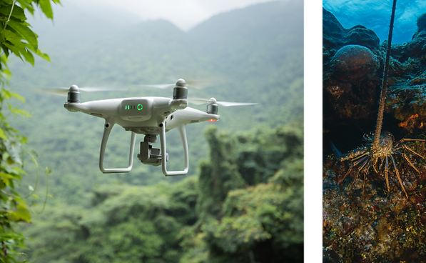
At Coastal Aerial Mapping & Inspections (CAMI), we specialize in providing state-of-the-art unmanned aerial systems (UAS) and remotely operated vehicle (ROV) services. We deliver innovative solutions for aerial and underwater exploration, mapping, and surveillance using advanced drone and submersible technology.


Our Services:
01.
Aerial Imaging and Mapping - High-definition cameras and geospatial technology deliver precise topographical and imaging data for agriculture, real estate, construction, and environmental studies.
02.
Underwater Exploration and Inspection - Our ROVs conduct marine life studies, inspect underwater assets like dams and vessel hulls, and inspect pipelines, including internal dredge float hoses.
03.
Aerial Imaging and Mapping - High-definition cameras and geospatial technology deliver precise topographical and imaging data for agriculture, real estate, construction, and environmental studies.
04.
Aerial Imaging and Mapping - High-definition cameras and geospatial technology deliver precise topographical and imaging data for agriculture, real estate, construction, and environmental studies.
05.
Aerial Imaging and Mapping - High-definition cameras and geospatial technology deliver precise topographical and imaging data for agriculture, real estate, construction, and environmental studies.
Industries Served
01.
Agriculture - Precision farming and crop health monitoring
02.
Real Estate - Detailed property surveys and promotional aerial imagery
03.
Construction - Site mapping, progress tracking, and safety inspections
04.
Environmental Studies - Monitoring pollution and ecological assessments
05.
Oil and Gas - Inspecting pipelines, storage tanks, and offshore platforms
06.
Utilities and Telecommunications - Infrastructure inspections of power lines, cell towers, and more
Truly Top-Notch Services
The CAMI team comprises certified UAS pilots and skilled ROV operators who understand each project's unique needs. We offer tailored solutions to fit your operations' specific requirements and constraints.

Experienced Professionals: Our team includes FAA-certified UAS pilots and skilled ROV operators, ensuring safe and efficient mission execution.

Cutting-edge Technology: We continually invest in the latest drone and ROV models, ensuring optimal performance and high-quality data.

Customized Solutions: We tailor our services to meet your specific project needs.

Safety First: We comply with U.S. and international safety standards, conduct thorough pre-mission planning, and perform regular equipment checks.

Eco-conscious Operations: We are committed to minimizing the ecological impact of our missions.
Specifications -
Equipment Portfolio
UAS Fleet
Our fleet features the DOD-compatible, NDAA-compliant Skydio X2E
ROV Lineup
Our lineup includes the Chasing M2 Pro Max Compact unit, which can perform shallow dives up to 600 feet and is equipped with manipulator arms and high-resolution cameras.
Contact Us
Elevate Your Vision Today
Discover how Coastal Aerial Mapping & Inspections can enhance your project with our advanced UAS and ROV solutions. Contact us today to learn more about our services or to schedule a consultation.

Experience the difference with Coastal Aerial Mapping & Inspections–where precision and innovation meet to elevate your project to new heights.